Transport · Map · 4 min read
Alto's High-Speed Rail Map: Seven Stops, a 15-km Tunnel and 130 km of Canadian Shield
Alto plans a Toronto to Québec City line with seven stops, but has not published an alignment. The Parliamentary Budget Officer's cost estimate of 75 to 113 billion dollars names the two stretches it treats as cost drivers: a tunnel under Mount Royal and the Canadian Shield.
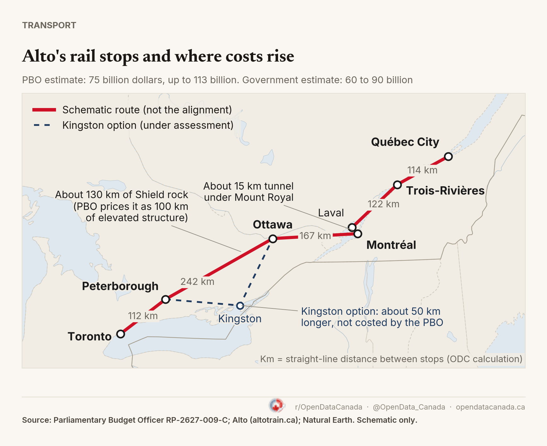
Where will Alto's high-speed rail run?
Alto, the federal Crown corporation planning Canada's high-speed rail line, says it will stop in Toronto, Peterborough, Ottawa, Montréal, Laval, Trois-Rivières and Québec City, across Ontario and Quebec. But the exact proposed route has not been published.
The map above is therefore a schematic, not the proposed alignment. It joins the seven planned stops in order so the geography is easier to see. Alto has shown only a generalised view of its route and has not released station sites.
The Parliamentary Budget Officer (PBO) has published enough to show where construction could get particularly difficult: about 130 km of Canadian Shield terrain between Ottawa and Peterborough, plus a 15 km tunnel under Mount Royal between Montréal and Laval.
How long is the line?
Alto describes the line as "approximately 1,000 km of dedicated and electrified tracks" for trains running at 300 km/h or more. The PBO assumes less. It uses 850 km as "an upper-bound assumption for the length of new track", noting that the driving distance from Toronto to Québec City via Montréal and Ottawa is under 850 km.
As a simple geographic check, the straight-line distances between the seven city-centre points add up to about 773 km (Toronto to Peterborough 112, Peterborough to Ottawa 242, Ottawa to Montréal 167, Montréal to Laval 16, Laval to Trois-Rivières 122, Trois-Rivières to Québec City 114). A real rail alignment would be longer, which makes the PBO's 850 km upper-bound assumption plausible. The gap between 850 and 1,000 km matters: the government's 60 to 90 billion dollar estimate is 71 to 106 million dollars per kilometre over 850 km, but 60 to 90 million over 1,000 km.
How much will Alto high-speed rail cost?
The PBO estimates 75 to 113 billion dollars, against the government's 60 to 90 billion. It names two stretches as the main cost drivers.
The Canadian Shield, between Ottawa and Peterborough. The PBO says about 130 km of this stretch could encounter Canadian Shield terrain, not necessarily continuous rock cutting. To meet the alignment that 300 km/h trains need, the report assumes extensive rock cutting, grading and filling. It treats each 1.3 km of Shield as equal to 1 km of elevated structure, which turns the 130 km into 100 km of elevated structure in its model. The PBO prices each additional kilometre of elevated structure at 153 million dollars (range 132 to 175 million). At that rate, those 100 km are worth roughly 15 billion dollars. That is our calculation, not a figure from the report. The PBO says rock cutting costs less than elevated track, which is why it counts 1.3 km of rock as 1 km of elevated structure.
A tunnel under Mount Royal. The PBO assumes about 15 km of tunnel to connect Laval and Montréal. The PBO prices each additional kilometre of tunnel at 169 million dollars (range 142 to 196 million), so the tunnel is worth about 2.5 billion dollars. Again, that multiplication is ours.
Applying the PBO's rates to those assumed quantities gives roughly 18 billion dollars. That is our calculation, not a figure published by the PBO. The two items are already part of the PBO's 75 to 113 billion dollar estimate (88 to 133 million dollars per kilometre), not an extra cost on top of it. The rest of the line is assumed to be cheaper. The PBO describes Montréal to Ottawa as "relatively straightforward" along the Ottawa River lowlands, and Montréal to Québec City as following the St. Lawrence lowlands with "little requirement for viaducts", though bridges will be needed in places.
The Kingston option
On June 22, 2026, the government directed Alto to assess a southern route between Peterborough and Ottawa with a possible stop in Kingston. The PBO says this could add about 50 km, but would be more level and avoid more of the Canadian Shield. The government has not released a revised cost for it, and the PBO did not cost it.
Our straight-line check agrees on the length. Peterborough to Ottawa direct is 242 km. Going through Kingston is about 293 km, roughly 50 km more.
What to watch
The exact route is still to be set, and it will decide how much of the line runs through rock. The Kingston assessment is the one to watch. The PBO says that route is more level and avoids more of the Canadian Shield, but it is about 50 km longer and passes through more settled and ecologically sensitive land, including the Frontenac Arch Biosphere. The PBO says this would bring more land acquisition, mitigation and consultation. For the full cost comparison with 94 high-speed lines worldwide, see our Alto high-speed rail cost analysis.