Economy · Energy
West Coast Oil Pipeline (Pacific Link): Route Map and Cost
Ottawa listed the Alberta-to-B.C. oil pipeline as a project of national interest on Oct. 1. Here is what the route, the cost estimates, the ownership plan and Trans Mountain's own record say about it.
Prime Minister Mark Carney on Thursday listed the West Coast oil pipeline as a project of national interest under the Building Canada Act, in an announcement from Fort McMurray. It also has a name now: Pacific Link.
Listing is not a construction permit. It moves the pipeline into a single federal review run by the Major Projects Office, with the Canada Energy Regulator holding public hearings. That review produces one "conditions document" that replaces the regulator's certificate and the separate federal permits for fish habitat and species at risk. Ottawa says it will finish those conditions by Sept. 1, 2027, "clearing the way to get shovels in the ground."
What was announced
- Owners: Canada and Alberta will own equal shares. Indigenous communities will be offered at least 10%, paid for with federal and Alberta loan guarantees. Pembina Pipeline is a private investor. Trans Mountain Corporation, the federal Crown company that built the last West Coast line, is leading development.
- Route: a southern route to Roberts Bank near Delta, B.C. Ottawa says this "protects British Columbia's North Coast" and avoids sensitive ecosystems including the Great Bear Sea.
- Port: Ottawa says it is working to expand the container terminal at Roberts Bank "to export crude from Pacific Link."
- Consultation so far: the Major Projects Office says it consulted more than 130 Indigenous communities along possible routes over the past three months, plus the B.C. government.
- The government's claims: 140,000 jobs, more than 20 billion dollars a year in GDP, and 100 billion dollars in government revenue by 2060. Alberta's finance department separately estimates more than 265 billion dollars in extra royalties for the province over the pipeline's 50-plus years. These are the governments' own projections. Neither release shows how they were calculated.
Where it would go
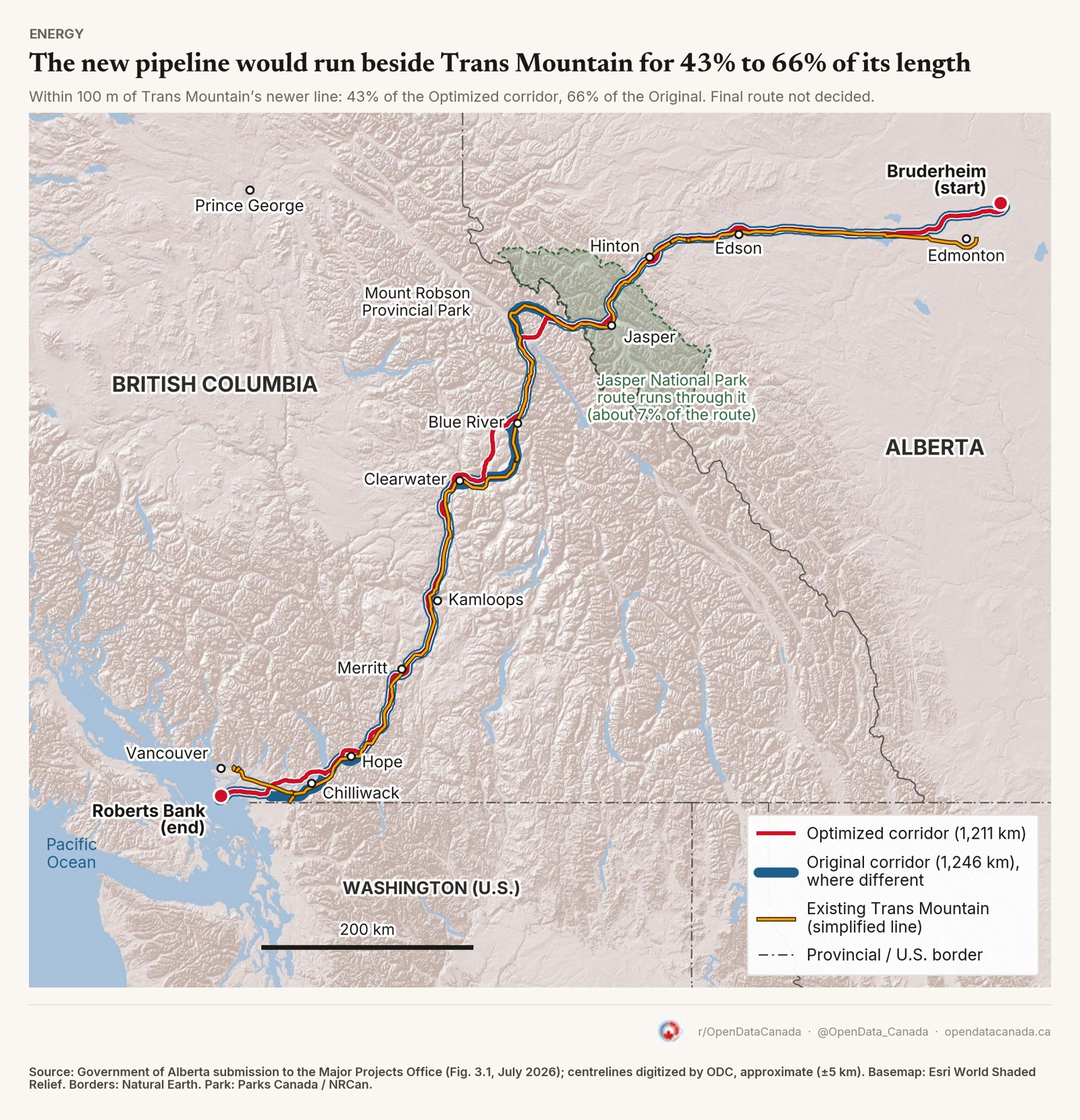
No official route map has been published. We traced the one above from a figure in Alberta's July filing to the Major Projects Office, so it is approximate (give or take about 5 km). The final route is still to be set during the review.
- Start and end: Bruderheim, Alberta (northeast of Edmonton) to Roberts Bank.
- Length: 1,211 km on Alberta's "Optimized" route, 1,246 km on its "Original" route.
- Beside Trans Mountain: the new line would run right next to the existing pipeline (within 100 m) for 43% of the Optimized route and 66% of the Original.
- Already disturbed ground: 82% of the Optimized route and 92% of the Original stay within 100 m of land that is already cleared or built on.
- Jasper National Park: about 7% of the route goes through the park.
The project in numbers
| Item | What the filing says |
|---|---|
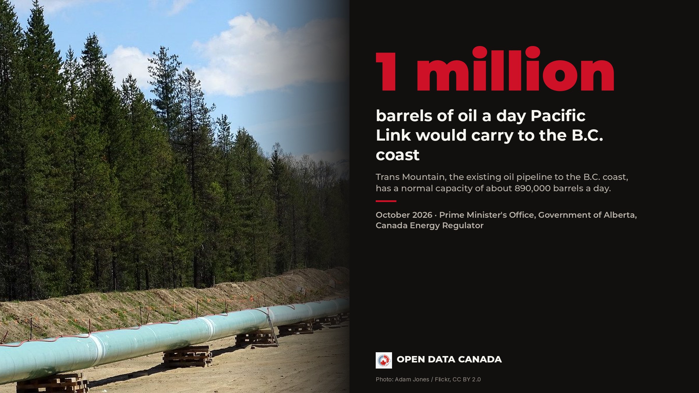
| Size | 1 million barrels of oil a day |
| Cost | $35.2 billion if finished in 2032, or $43.7 billion if finished in 2034 without a sped-up approval. Excludes inflation and financing costs during construction |
| Pump stations | about 11 |
| Indigenous groups whose territory it crosses | about 90 to 125 |
| First Nations reserves crossed | 9 to 11 reserves, about 13 to 14 km in total |
| Oil terminal | two berths at Roberts Bank for very large tankers |
| Greenhouse gases from producing the oil | 15.5 to 18.2 million tonnes a year (2032 to 2041) |
| Greenhouse gases from running the pipeline and terminal | about 0.2 million tonnes a year |
These are Alberta's July estimates. Thursday's announcement did not include a new cost figure. The 44 billion dollar number in many headlines is the slower-approval case. The cheaper 2032 figure assumes a sped-up approval, and it still leaves out inflation and borrowing costs.
Is Trans Mountain full?
The case for a second line rests on the first one filling up. The Canada Energy Regulator publishes how much oil Trans Mountain carries each month.
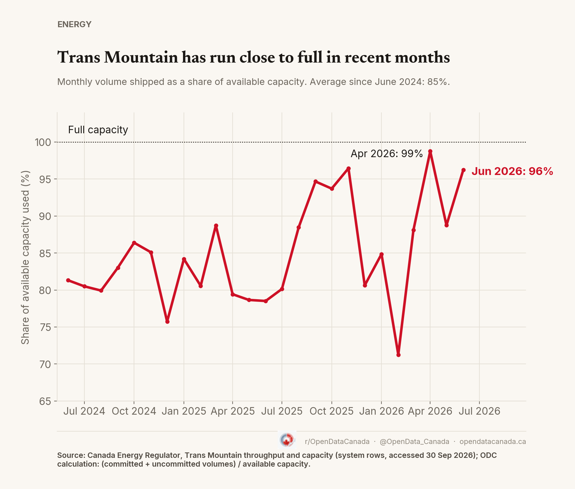
In June 2026, the latest month available, Trans Mountain carried 96% of the room it had that month. Since June 2024, its first full month after the expansion, it has averaged 85%. In 2025 it had room for 892,000 barrels a day on average and carried 761,000. "Room available" moves from month to month because of maintenance, so a single month near 100% is not the same as being full all year.
Did the last pipeline cut reliance on the US?
Ottawa's release says Pacific Link "will reduce our dependence on the United States." Trans Mountain's expansion is the only real test of that idea so far.
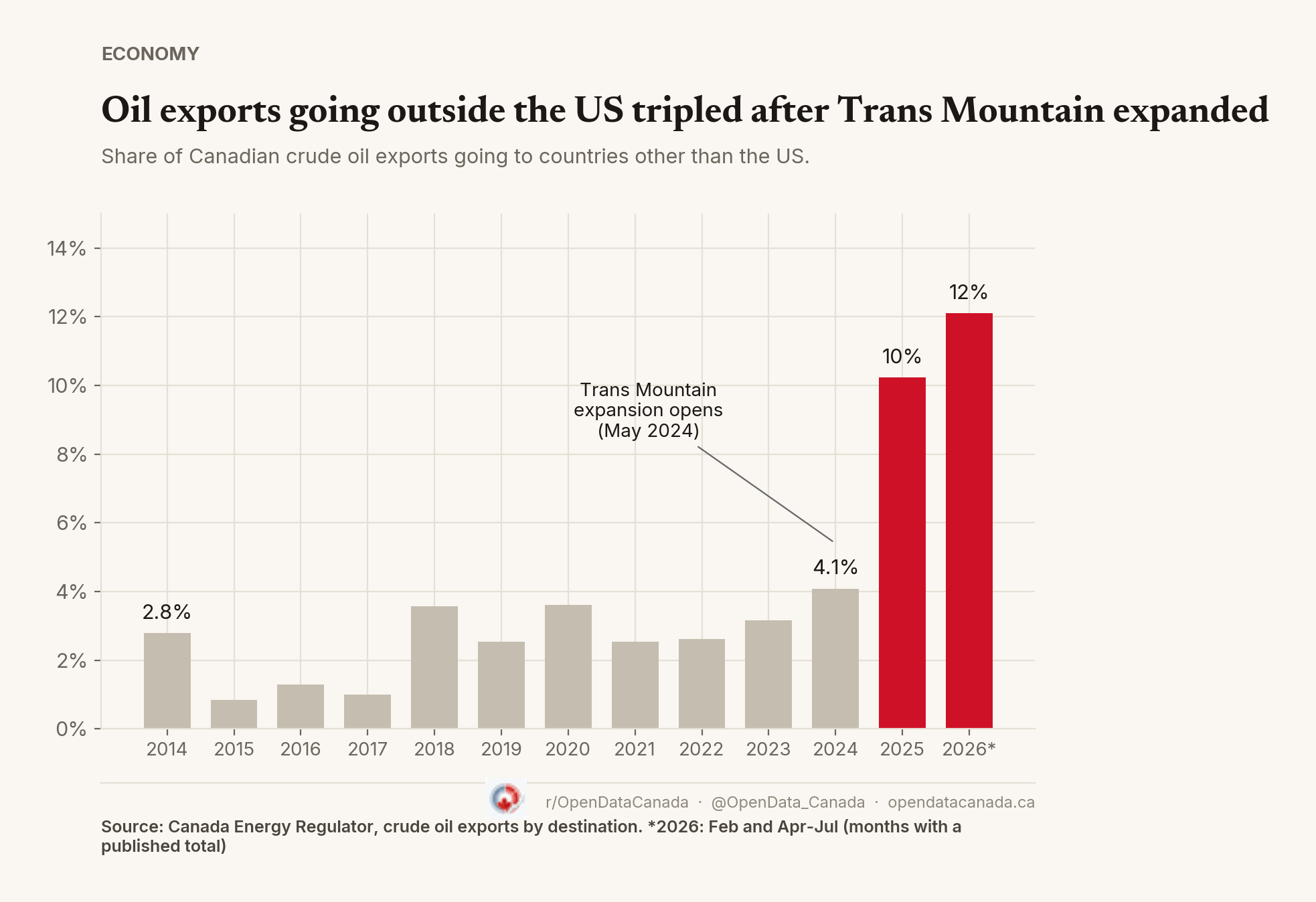
It worked, up to a point. Before the expansion opened, between 1% and 4% of Canada's crude oil exports went anywhere other than the US (3.2% in 2023). In 2025, the first full year with the new line, that rose to 10.2%. In the months of 2026 with published totals it was 12.1%. Even so, the US still took about 88% of the crude oil Canada sold abroad this year. A second West Coast pipeline would add another export route, but it would not make the US a small customer.
The rules it runs under
Ottawa has also introduced Bill C-39, the Building Canada Strong Act. It would require a decision on pipelines within one year of the government getting the information it needs, and make the Canada Energy Regulator's commission the only body that assesses them. The bill is still at second reading in the House of Commons and could change.
The federal government says the bill brings "greater speed, certainty, and predictability." Greenpeace Canada calls it "The Bulldoze Nature Bill." The Centre québécois du droit de l'environnement, a Quebec environmental law group, warns a one-year deadline is too short to properly assess complex projects. The Western Business Coalition welcomed "the one-year timeline."
Two things the filing leaves open: how many rivers and streams the line would cross (it names 16 major ones, including the Fraser, Thompson and North Saskatchewan), and what tanker spill response would be required, which it calls "yet to be determined." Its emissions estimate also leaves out the Pathways carbon-capture project, which Ottawa's release presents alongside the pipeline.
What Thursday settled is that Ottawa wants this built. What it did not settle is the price, the final route, or who pays if the cost runs over, and the review that answers those questions has 11 months to do it.
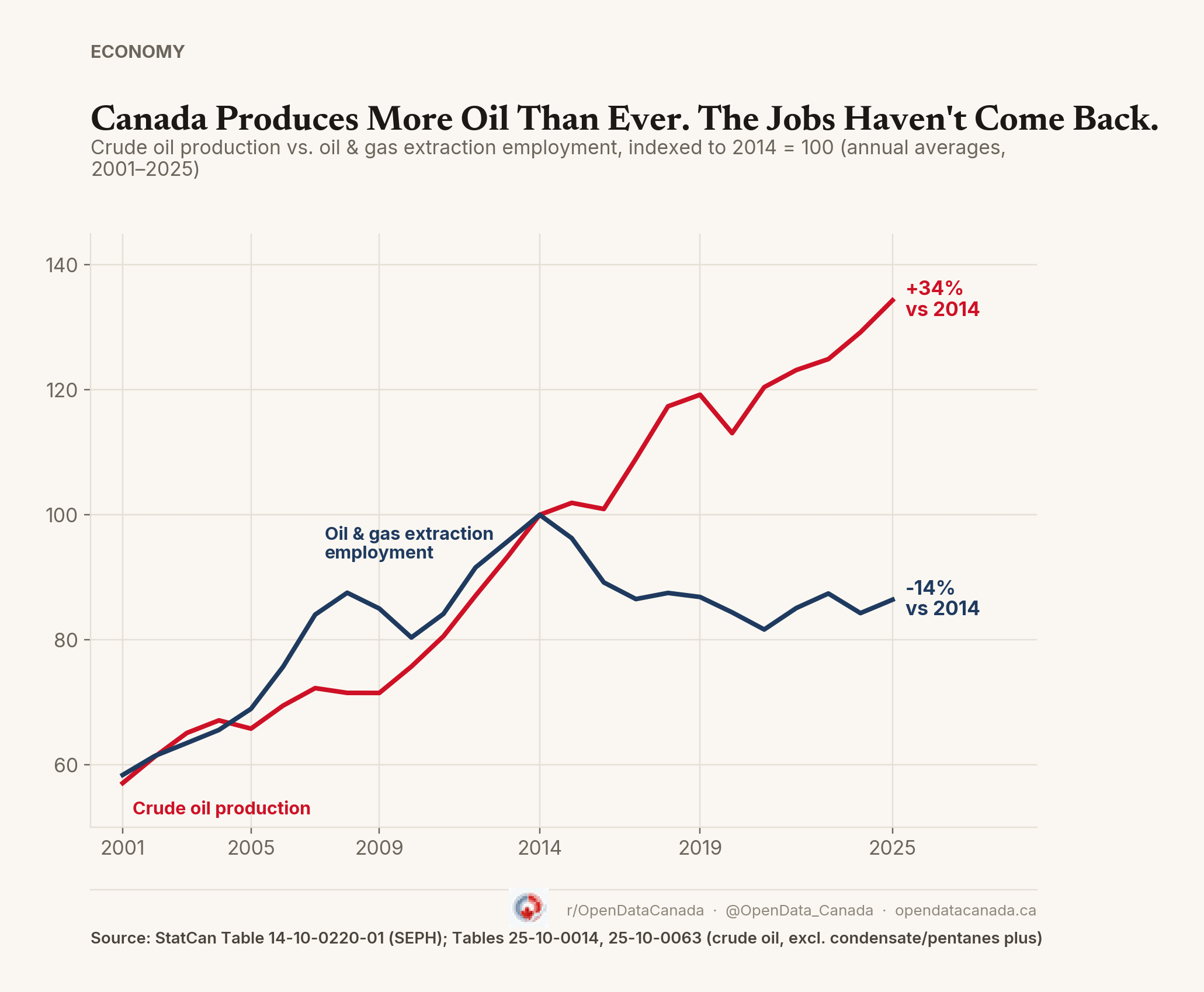
See also: where Canada's oil goes and why record oil output hasn't brought back the jobs.