
Geography · Trade · Chart
How much of each Great Lake is in Canada? Ontario 55%, Huron 61%, Michigan 0%
Splitting each Great Lake along the International Boundary Commission's surveyed line, Canada holds 61% of Lake Huron, 55% of Lake Ontario, about half of Lake Erie, 36% of Lake Superior and none of Lake Michigan — 37% of all five lakes combined. The split is back in the news because President Trump's August 27, 2026 order renamed Lake Ontario “Lake America” inside the United States.
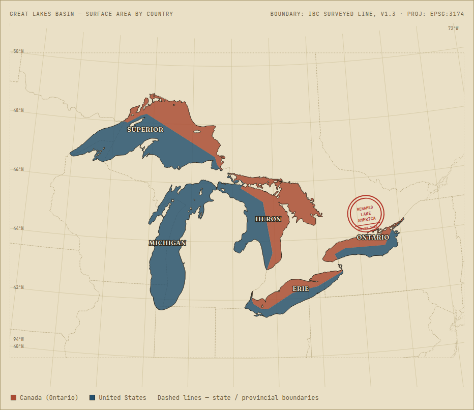
What the chart shows
Each lake's polygon was cut along the actual surveyed Canada–U.S. boundary — the International Boundary Commission's official digital boundary (shapefile v1.3, built from NAD83 survey monuments and shore turning points dating to 1817–1820) — not a generalized country outline. The pieces were then assigned to Canada or the U.S. and summed in EPSG:3174 (NAD83 / Great Lakes & St. Lawrence Albers), an equal-area projection.
| Lake | Total km² | Canada km² | U.S. km² | Canada share |
|---|---|---|---|---|
| Superior | 82,311 | 29,460 | 52,851 | 35.8% |
| Michigan | 57,541 | 0 | 57,541 | 0.0% |
| Huron | 59,937 | 36,550 | 23,387 | 61.0% |
| Erie | 25,736 | 13,002 | 12,734 | 50.5% |
| Ontario | 19,464 | 10,653 | 8,810 | 54.7% |
| All five lakes | 244,987 | 89,664 | 155,323 | 36.6% |
Each lake has its own page with a larger map: Lake Superior · Lake Michigan · Lake Huron · Lake Erie · Lake Ontario.
Lake Michigan is the only Great Lake entirely inside the United States — it never touches the border. Lake Ontario, the one Trump's order renamed, is one of two lakes, with Huron, where Canada holds a clear majority of the surface area.
Lake Erie is effectively a coin flip. This method puts it at 50.5% Canadian; a coarser cross-check using generalized country polygons instead of the surveyed line puts it at 49.6%. The two methods agree to within about a percentage point on every lake, Erie included — but Erie's boundary runs so close to the lake's geographic center that this small a gap is enough to flip which country holds the nominal majority. Treat Erie as roughly even, not a confirmed edge either way.
Common questions
What percentage of Lake Ontario is in Canada? 54.7% of its surface area (10,653 of 19,464 km²). It is the lake where Canada holds the second-largest share, after Huron.
How much of Lake Erie is in Canada? About half: 50.5% by the surveyed boundary. A coarser method gives 49.6%, so treat Erie as an even split.
Is Lake Michigan in Canada? No. Lake Michigan lies entirely inside the United States and never touches the border.
Which Great Lake is entirely in Canada? None. Michigan is entirely American, and the other four are shared. Huron has the largest Canadian share at 61.0%.
Who owns the Great Lakes? The lakes are divided along the international boundary. By surface area Canada holds 36.6% of the five lakes combined (89,664 of 244,987 km²) and the United States holds 63.4%.
Is there a map of the Canadian share of the Great Lakes? Yes, the map above shades each of the five lakes by country. It covers the Great Lakes only, not all lakes of Canada.
The Lake America order
Trump signed the order Thursday afternoon in the Oval Office, effective “immediately,” following through on a threat made on social media earlier in the week. It follows the collapse of U.S.–Canada trade negotiations and is widely covered as an escalation — reported by CNN, USA Today, CNBC, Politico, The Guardian, and the AP.
The order only changes the name as used within the United States. Canada has given no indication it will adopt “Lake America” — and by this analysis, Canada holds the larger share of the lake's surface anyway.
Lake Ontario, 55% Canadian, is also running unusually high this year: its provisional September 2026 level is 40 cm above its long-term average for the month. See 2026 water levels for all five lakes.
Read next