
Environment · 3D map
Bedrock geology of British Columbia and Alberta
The parallel stripes running down the Rockies are thrust sheets: layers of rock from several eras, stacked on top of each other and shoved north-east onto the plains. Here they are on real terrain, coloured by the age of the bedrock.
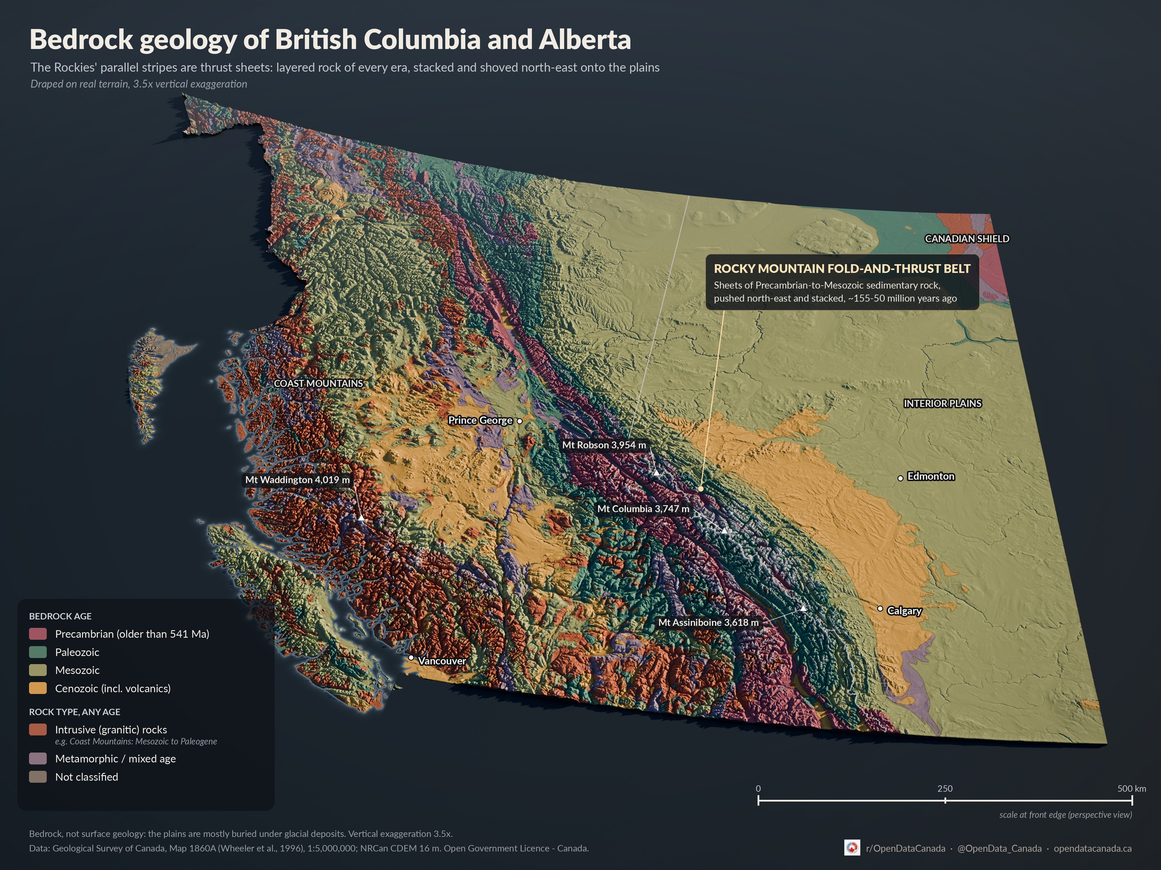
On a phone the labels on the map are small. Tap the map to open the full-size version, or use this key.
Bedrock age
- Precambrian (older than 541 Ma)
- Paleozoic
- Mesozoic
- Cenozoic (incl. volcanics)
Rock type, any age
- Intrusive (granitic) rocks
- Metamorphic or mixed age
- Not classified
Places on the map: Vancouver, Prince George, Edmonton and Calgary. Peaks: Mt Waddington (4,019 m), Mt Robson (3,954 m), Mt Columbia (3,747 m), Mt Assiniboine (3,618 m). The Rocky Mountain fold-and-thrust belt runs diagonally through the middle; the Canadian Shield is in the far north-east.
How to read it
Each colour is the age of the solid rock that sits under the soil, gravel and ice: oldest (Precambrian, more than 541 million years old) in pink, then Paleozoic in green, Mesozoic in olive and Cenozoic, the youngest, in orange. Some rock is shown by type rather than age. Granite-like rock that cooled from magma underground is rust red, and rock reworked by heat and pressure, or mixed in age, is mauve.
The Rockies. The diagonal stripes running north-west to south-east through eastern B.C. and western Alberta are the Rocky Mountain fold-and-thrust belt. Sheets of Precambrian-to-Mesozoic sedimentary rock were pushed north-east and stacked, roughly 155 to 50 million years ago. That is why old and young rock alternate in narrow bands across the range instead of sitting in one neat pile.
The Coast Mountains. Most of the coast is rust red: large bodies of granitic rock, Mesozoic to Paleogene in age. Mount Waddington (4,019 m) sits in this belt.
The plains. East of the mountains, Alberta's bedrock is mostly Mesozoic, with a band of younger Cenozoic rock along the foothills, from south of Calgary to west of Edmonton. In the far north-east corner, the much older Canadian Shield comes to the surface.
What this map does not show
This is bedrock, not surface geology. Across most of the plains, the rock shown here is buried under glacial deposits, so a field on the Alberta plains usually sits on sediment left behind by ice sheets, not on the colour shown here. The source map is drawn at 1:5,000,000, which means small rock units are merged into their neighbours. It is a regional picture, not a guide to what lies under any one property.
Heights are stretched 3.5 times so the terrain reads at this scale, and the view is in perspective, so the scale bar holds only along the front edge.
For another view of the same two provinces on real terrain, see 26 years of BC and Alberta wildfires, animated.
Read next